
Explore the early History of Lawrence County, Ohio, by reading stories from villages, communities, townships, and other places. We focus primarily on the early 19th and 20th-century people, places, and businesses and how they shaped our county.
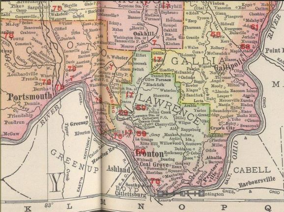
Lawrence County, Ohio, is the most southerly point in the state. It runs adjacent to the Ohio River and borders West Virginia and Kentucky. Before its organization, our parent counties were Washington, Gallia, and parts of Scioto Counties in Ohio. Most early pioneers immigrated from Virginia, New England, or other countries such as Ireland, Germany, France, Great Britain, etc.
The early iron furnaces brought a booming economy to our area. This resulted in other industries and factories establishing businesses to provide essential commodities to the workers who moved here, as well as new housing and the building of communities and towns.
Reading these stories below will teach you about your ancestor’s hardships, tragedies, accomplishments, joys, and sadness in their lives. We hope you enjoy our series and look around The Lawrence Register website for additional historical and genealogical information.
Lawrence County, Ohio, is divided into fourteen townships, each with its own history and communities. Exploring these townships can help researchers discover where their ancestors lived and settled.
The southern portion of Lawrence County follows the Ohio River, bordering Kentucky and West Virginia. Streams, creeks, and other waterways also played an important role in early transportation and settlement throughout the county.
- 1855 Agricultural Society News
- 1884 – Death In Deluge Flood
- 1884 – Great Flood
- 1887 – The Ohio River
- 1901 Earthquake in Southern Ohio
- 1907 – July Flood Story
- 1937 Flood Chronicles
- 1937 Flood Photos
- 1937 Flood Passes 1913 Deluge by Five Feet in Lawrence County, Ohio
- 1937 Flood Wall Holds But City Quits Pumping Sewers
- Abandoned Towns in Lawrence County
- About Uncle Purl Willis—The son of the late Rev. and Mrs. J.H. Willis said that since 1931, he has appeared before Congress 100 times and is aiding the 46 Indian bands of California in establishing their rights under a Supreme Court decision of November 1941.
- Accident of Isaac Thacker 1904
- Aid, Ohio Early News
- Among the Skeletons – Lawrence County, Ohio
- An Old Timer – Mound Builders in Union Landing
- Andis, Ohio Early News
- Antiquities In Lawrence County, Ohio
- Athalia, Ohio Early News
- Band of Counterfeiters 1875
- Bartramville, Ohio, Early News
- Bay Boats Steamboats
- Blackwell Gang of Counterfeiters – 1881
- Bible Records
- Biographies of persons in Lawrence County, Ohio
- Births from Lawrence County, Ohio
- Bloody Affray in Lawrence Co., Ohio, 1850
- Boggs, Andrew 1836
- Bradrick, Ohio, Early News
- Brooks, Lewis Sr. Obituary
- Burlington Index
- Bush, S. R. Reminisces about Ironton’s early newspaper
- Cemeteries in Lawrence County, Ohio
- Cemeteries - Index of persons and where they are buried in Lawrence County, Ohio
- Cemeteries - Headstone Photos
- Cemeteries - Inscriptions, stories, photos, and more
- Cemeteries - Locations
- Chesapeake, Ohio Airport
- Chesapeake, Ohio – History Book in progress
- Chesapeake, Ohio - Early Names
- Chesapeake Becomes a Village
- Chesapeake, Ohio - The night the gangsters came to Chesapeake, Ohio.
- Cherokee National Council Citizenship Record of Hiram Wilson, Wayne County, WV 1894
- Churches and their history, along with some photos
- Coal Grove Growth 1891
- Collier and Davis Kidnapping
- Commissioner Minutes #1 – 1817
- Commissioner Minutes #2 – 1817
- Commissioner Minutes #3 – 1817
- Common Pleas Court Session 1820
- Confession of Counterfeit Company 1837
- Connelly, John Reminisces
- Cooper, David Reminisces
- Copy of the Lawrence County Gazette 27 Oct. 1849
- Counterfeit Cases 1859
- Counterfeit Ten Dollar Bill 1850
- Counterfeiter Arrested 1855
- County Notes by Pilgrim - 1887 - 1892
- Courthouse records 1819-1820
- Crown City History
- Daniel Boone's Old Stone was found with his name carved in it
- Davisson, Robert Reminisces
- Deaths from Lawrence County, Ohio
- Deed Indexes - incomplete
- Deering, Ohio - Old Country Store
- Deering, Ohio, Hosts the G.A.R. 5th Reunion
- James Ditcher, an Underground Railroad Operator, Interviewed
- Divorces taken from early newspapers
- E.F.F. Furnaces Reminisces 1899
- Early Court Records
- Early Deeds & Guardians 1817 – 1824
- Early Families from Lawrence County, Ohio
- Early Furnaces 1904
- Early Marriages 1817 – 1820
- Early Marriages 1817 – 1823
- Early Marriages 1819 – 1821
- Early Masons - Briggs Library - 9 March 1905
- Early Lawrence County History – July 1888
- Early Settlers and Pioneers
- Elizabeth Blake - A Medium Psychic from Bradrick, Ohio
- Exodus of 37 Blacks from Virginia to Burlington in 1849
- Experience With a Panther
- Families
- Fifty Emigrants went to Oregon from Lawrence County, Ohio - in 1883
- Finley Family
- First Happenings in Lawrence County, Ohio
- First Saw Daylight - This is where some of the prominent citizens in Lawrence County, Ohio, were born and the year in some instances.
- Former Lawrence Countians - Where Did They Go?
- Four Men Drowned – The Terrible Accident that Befell Italian Laborers While Crossing the River in a Skiff.
- Frampton Family, their ferry and post office - Early history of Chesapeake, Ohio.
- French Grant
- Fugitive Enslave Case
- Getaway, Ohio Possesses Odd History Part One and Two
- Getaway, Ohio History Part Three
- Getaway, Ohio History Part Four
- Ghosts Stories
- Gideon Bragg, a war veteran, married a girl of seventeen
- Gillen, Elijah Letters and Mary Moss Winkler Letter – Submitted by A.K. Stoddard
- Glacial Boundary in the Ohio River
- Gordon, Mary Counterfeiter 1878
- Greasy Ridge Notes
- Haircuts At Premium During Lawrence County, Ohio Flood
- Hanging Rock, Ohio, in the 1800s
- Haverhill, Ohio
- Higgins, R.W. Counterfeiter 1880
- Hiram Hagerman’s Accident
- History of Ohio River Crests 1832-1939
- Holt, Albert – full obituary
- How Some Enslaved Persons Weren’t Caught
- Imes – Early History No. 3 – 16 Mar 1899
- Imes - Revisiting Lawrence County - 26 Jan 1891
- Indians – At Lake Vesuvius
- Indian Skeleton is Found by Scouts Old Mound at Kouns Property at Sheridan, Ohio is Opened
- Iron Furnaces - History, photos, stories, and biography of Iron Masters
- Ironton, Ohio Fires
- Ironton, Olio - Historical stories, photos and more
- Ironton, Ohio Practically Disease Free Due To Efficient Medical Set-Up During The 1937 Flood
- Irwin, Grandpa Reminisces
- Irwin, John T. – writes of a visit back to the county on 31 Aug 1899
- Jos. Hardesty – Blown Fifty Feet in the Air
- Kansas Letter 5 Feb 1891
- Kansas Stories about Lawrence County, Ohio, persons
- Kellogg Powder Mill Explosion – destruction to Burlington Ohio Courthouse
- Kelley’s Bridge School Tragedy
- Kelly’s Farm [W.D.] – taking a stroll through it – 1858
- Kounston - A town founded by Andrew P. Kouns, now West Chesapeake, Ohio
- Lawsuit about Samuel Langdon’s farm and Hammond Howe
- Lawrence City - Early name for Chesapeake, Ohio
- Lawrence County, Ohio -Laborers Wanted 1845
- Lawrence Mill Explosion 1887
- Lawrenceburg - Was once the name of Chesapeake, Ohio
- Hon. Ralph Leete represented Polley, who was enslaved and resold back into slavery.
- Letter from H. W. Parker - 1858
- Macedonia Church - Burlington, Ohio
- Making of Clothes & Shoes – 1904
- Mason Township Pioneers
- Marriages from Lawrence County, Ohio
- Mary Bush and the Native Americans
- Massie and Corn Reminisces
- Memorial Day Origin - Rome Cemetery
- Memorial Hall - Ironton, Ohio
- Meteoric Shower in Rockwood, Ohio, and Ceredo, WV
- Military History of Lawrence County, Ohio - Stories, photos, Civil War, and other war information
- Miller, Edward - How he helped establish Chesapeake, Ohio
- Millersport Man Reminisces
- Millirons, Frank Alleged Leader of Counterfeiters 1900
- Mitchell, William plead guilty to counterfeiting tobacco stamps 1870
- More Counterfeit Cases 1859
- Morgan, Captain - Marriage
- Mound Builders 5 May 1892
- Names of old places in Lawrence County, Ohio
- Native Americans by Luke Kelley
- Notable Gunsmiths from Lawrence County
- Obituaries of Former Enslaved Persons
- Obituaries from Lawrence County, Ohio, 1850-1900
- Officers of the Court 1821
- Ohio River Boats
- Order of Twelve
- Origin of Local Names
- Organization of Lawrence County, Ohio – 1902
- Old Burlington Court
- Old Times Story About Mr. Moss at Burlington, Ohio
- Old Times By Captain Gillett
- Old Times By Charles Wilgus
- Old Times Incidents of Pioneer Life at Burlington, Ohio
- Old Times In Windsor, Rome, and Union and the early navigation on the Ohio River
- Old Times With General Fuller and other stories
- Old Resident Writes about Lawrence County, Ohio
- Ozarks of [Lawrence County] Ohio
- Paddy Creek News
- Patents and Inventors
- People he met in the West
- Pioneers from Lawrence County, Ohio
- Places in early Lawrence County, Ohio
- Poll Book 1815-1816 & Early Families
- Pratt's Farm and Greenhouse Videos on YouTube
- Proctorville 1900 Fire Destroys Half of Village
- Proctorville, Ohio History
- Proctorville News 1888
- Quaker Bottom History
- Quakers, Mennonites, and Omish [sic] History
- Ralph, Charles H. – Names are taken from his diaries
- Rankins, Armstrong, and Hannah on Oak Ridge
- Rappsburg, Ohio
- Real Estate Boom in Rural Lawrence County, Ohio, 1952
- Reminiscences of a Millersport Man
- Reminiscences of the West – as told by Col. John Johnston
- Roadbuilder Pioneer Reminisces
- Mr. Roberts and Mrs. Rand Reminisces about Ironton’s first lawyer
- Robinson, Elias Asa – Civil War Diary
- Rockwood, Ohio, Early Snow Story in 1847
- Rockwood, Ohio History
- Rockwood, Ohio Meteoric Shower 1889
- Rockwood, Ohio Storm Damage 1903
- Rock Camp United Methodist Church and General Store
- Rome Township Pioneers
- Rome Village Fire in 1932
- Russell, Gertrude, Mrs. Counterfeiter 1890
- Russell’s Place – Some Chips Gathered in Old Windsor
- Russell's Place, Ohio, News
- Sandy Valley - 1892
- Schools - History, stories, and photos
- Scottown – Photo of Lemley’s store, which later became Holschuh’s
- Searching for Poke Patch
- Seibert’s List of Underground Railroad Operators in Lawrence County
- Sheridan Coal Works
- Sherritt's, Ohio news
- South Point, Ohio – Noted Men
- South Point, Ohio, was the site of silver and tin on the property
- Stewart and Lambert Story in Union Church
- Sunday School, First -4 May 1876
- Symmes Creek - Farm for Sale
- Symmes Township Pioneers
- Tax Indexes - 1818 and 1820
- Texas Letter 1905
- Through the County – 1869
- Tolliver, Aleck
- Rev. William H. Tope
- Twyman Training Center – A short documentary detailing the story of a training center lost to time in Burlington, Ohio.
- Union Township Early History - Chesapeake Book
- Union Township Pioneers
- Upper Township Pioneers
- Vesuvius Lake History
- Voting in the county sixty years ago - 19 Feb 1891
- Ward Lumber Company Fire 1911
- Walton, Thomas
- Walton Writes a Letter to English Newspaper 1872
- Waterloo ties to Abe Lincoln
- Who Killed Andrew Boggs
- Woodland Cemetery Burial Index - Ironton, Ohio
- Will Index 1847 - 1941
- Willow Wood, Ohio
- Wilson, Theodore – An enslaved man who made good
- Windsor Township Pioneers
- Ye Olden Times 1902 Letter
- Yellow Poplar Lumber Fires
- Rev. Jacob Young