
Edward Miller was the first landowner in Chesapeake.
Chapter Three
Edward Miller was born in Shenandoah County, Virginia, in February 1752. In 1779, at the age of 27, he enlisted in the Revolutionary War from Augusta County, Virginia. He was captured and held as a Prisoner of War from the Spring of 1780 until June 1781, when the British exchanged him and landed him near Williamsburg, Virginia, on the James River.
Around the same time, the James River and the Kanawha River [known as the James River and Kanawha River Turnpike, now Route 60] were among the earliest means of travel from the colonial states to the adventurous Northwest Territory. Many frontiersmen arrived at the forks of the Guyandotte and Ohio Rivers, and traveling just a short distance downriver, they would find themselves at the mouth of Indian Guyan and/or Symmes Creek. These waterways landed them directly at Union Township, where they established small communities later known as Quaker Bottom, Bradrick, Coryville, and Chesapeake in Lawrence County, Ohio.
On 1 September 1787, Miller, age 35, married Rebecca Colwell in Shenandoah County, Virginia. The year before they married, a few prominent men from New England formed The Ohio Company. When Edward learned about the new land opportunities, he moved his family from Virginia and settled in what was then called ‘Washington County, Ohio.’
 Edward Miller shows up as one of the earliest Northwest Territory residents, and we can prove that because he was listed in the 1801 early Tax List in Waterford, Washington County, Ohio.
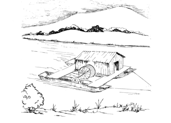
During 1781 and 1787, Edward Miller learned many talents and occupations. His essential qualities were being a surveyor and tavern owner, making liquor [Miller was German who owned his tavern], and possibly building and maintaining a “floating mill.”
New Englanders learned about floating mills from France and Holland, and they first appeared in the Northwestern Territory in Washington County, Ohio, where Miller resided. These mills were hard work but successfully avoided the Native Americans, land disputes, taxes, and property rents. This lucrative business would have helped Edward purchase property around the Ohio River and other waterways.
Two years later, Ohio officially became a State, and Edward Miller, along with Abraham Miller and Jacob Miller, are listed on the 1810 Resident Land Tax List of Gallia County, Ohio. [Gallia County, Ohio, Residents 1800 – 1825 by Dennis R. Jones].
As Edward Miller began buying property in Gallia County, Ohio, his ambition was to build a town. He successfully purchased, surveyed, and drew a plat map with 87 lots for sale, then recorded these towns as Washington and Lawrenceburg.
- The “Town of Washington” was located on the west side of Symmes Creek, with the Ohio River on the entire Southern portion of his town. He recorded it at the Gallia County, Ohio Courthouse on 22 Sep 1815. but as soon as Lawrence County, Ohio, was formed, one of the first entries in the Lawrence County, Ohio, Clerk of Courts Journal 1 & 2, page 10 was Edward Miller’s request that his “Town of Washington” be vacated, which the court granted on March 1818.
- The “Town of Lawrenceburg” was mentioned in the previous chapter of this book. Edward Miller recorded the town on 5 Apr 1823 at the Burlington Courthouse. If you view the plat maps of Washington and Lawrenceburg side by side, they are the exact location and the same number of lots, waterways, etc. The only difference is that Lawrenceburg had a “Public Square” in the southeastern center of the town.
The Ohio Company
[To read more about the Northwest Territories and the Ohio Company, click here]
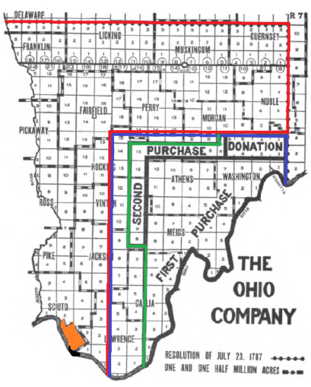
One of the first contracts of The Ohio Company was focused on surveying and buying land from Marietta, Ohio, to the lands opposite Huntington, WV. This included eastern Chesapeake, Union Township, and Lawrence County, Ohio.
From the Ohio Company map [courtesy of Wikipedia], Lawrence County, Ohio, was split between several purchases. [The one we are focusing on is the tiny square with the number 1 at the very bottom, along the Ohio River].
Agencies
To make it faster and more efficient, the Ohio Company formed sixteen groups of surveyors or “Agencies,” with one man as the “Leader.” That “Leader” would then hire the best surveyors, long hunters, and land speculators who were required to keep precise details of their work in old Ledgers. One of those groups was called “Parson’s Agency,” led by one of the Ohio Company founders, a Major General in the Continental Army named Samuel Holden Parsons.
Edward Miller is first mentioned as working with the Ohio Company in “The Register of Deeds Executed by Rufus Putnam, Manasseh Cutler, Robert Oliver, and Griffen Greene of Shares in the Ohio Company given in May 1792,” and acquired his first ‘payment’ of 276 shares in 1797. This crucial document gave Edward his first land ownership in the new state of Ohio. Let’s examine this old Ledger below and explain what it means. But first, I have added a disclaimer about some issues and discoveries common in early hand-written documents.
Disclaimer – Several sections are in this ledger, and it was challenging to research, as there is no index. By carefully going through the entire ledger, page by page, I found an essential fact that Edward Miller was one of the first pioneers of Ohio. Even though the title of the Ledger claims the dates cover the years between 1786 and 1796, there is a discrepancy in the document below, with the date on the page written as March 1797. – Martha
Deeds in Trusts to Lundry Agents – Dated March 7th, 1797
R.J. Meigs, Jr.
Edward Miller
Number of Shares
276
In Whole Agency
Parsons Agency
Remarks
Drawn Joshua Parsons

Ohio Company Plat Map
An additional document was found in yet another Ledger for the Ohio Company, “Plat Maps Surveying-Southeast Ohio,” on the same website. [see the following figure below]
This description is given on their website: “[The] first page is “[The] Map of the Ohio Company’s Purchase,” showing ranges and townships, major settlements, and waterways. Individual township maps follow, accompanied by names of original proprietors. The last section of the book contains maps of donation land allotments.” Creator: Ohio Company (1786-1796). Publisher: Marietta College, Special Collections.

Ohio Company Plat Maps Survey of Southeast Union Township, Lawrence County, Ohio
The First Settlers
You can barely read Edward Miller’s name on the above map next to the arrow. “Sold E. Miller” is faintly written, and his property is listed as #739 in one of the first surveys drawn by The Ohio Company. East of Edward’s property, there is one empty lot between Edward Miller and H. [Henry] Coonts [sic] Kouns, #737,
Continuing eastward up the Ohio River, the same map gives more early property owners in Union and Rome Townships in what would later become Lawrence County, Ohio. These names will familiarize researchers and historians as the early pioneers in Chesapeake, Bradrick, and Proctorville, Ohio.
The early property numbers associated with landowners are as follows:
- #731-732 is P. T. or A. Kimball [could be Titan or Asa]
- #733 N. [Nathaniel] Pritchard
- #734 J. [Joel] Gillett
- #735 Empty Lot
- #736 is A. P. or T. Kimball [could be Titan or Asa]
- #737 H. [Henry] Coonts
- #738 Empty Lot
- #739 E. [Edward] Miller
The last triangle in the orange block doesn’t include a number and is challenging to cipher, but it looks like it was written as “sold to J. [Joel] Bowman.” Outside the orange border is “Common” with the name written as “Jno. R. Atchinson 37.8.” This entry means John R. Atchinson owned 37 and 8 one-hundredths of acreage.
Charles Wilkes purchased 107 acres of “common” land north of these properties in this documented survey map. Written in faint pencil and still going eastward up the Ohio River towards Proctorville are the following names: Gardner, Goodhard [sic-also spelled Goodard, etc.], Gillett [sic – also spelled Gillette], Locy [sic – also spelled Lacy, Locey, etc.], Hall [could also be spelled Howe], Campbell, I. Lowe, McCan [sic – also spelled McCann] and finally, Swain.
Some names have small square boxes drawn by the surveyor beside them, indicating homes or other buildings on the property. There isn’t a date on the above map, but the description on the Marietta College website gives the years between 1786 and 1796. In early laws, ‘squatters’ could claim ownership of lands as long as they made improvements and had buildings on their ‘property. Perhaps that is how these early families acquired the land this map depicts them owning, but without further research, this is just speculation.
Congress Lands
The Congress Lands and the Ohio Company were two distinct companies operating under different laws on how pioneers could obtain land in Ohio. The early Ohio surveys and boundaries were confusing before, during, and even after the Northwestern Territory was established. Many problems plagued the Government during the early settlement of the State of Ohio, and you will find that reinforced by all the lawsuits that were later filed for ‘trespassing” between neighbors.
Congress passed the Harrison Land Act (Congress Lands) on 15 April 1800 to enable individuals to purchase land on credit, with a minimum of 320 acres. The Government thought this Act would clear up some of the problems with landowners and encourage others to buy land in Ohio.
But it became much more complex.
- Once a person decided they wanted to purchase land, the buyer had to travel to one of the Land Offices [in this instance, it was in Chillicothe], where they would make a land claim from the Registrar of the Land Office, who would then issue the buyer a Certificate or Patent.
- This Patent was sent to Washington, D.C., where the President of the United States had to sign each certificate.
- That Patent was then returned to the Land Office, where it originated, for the land owner to pick up.
- The new landowner would then make another trip to the Land Office and pick up his Patent with the President’s signature.
- Then, the buyer would have to travel to the Recorder’s Office in the County where the property was located and pay a recording fee to the Recorder’s Office.
- The Recorder would handwrite that Patent into their Deed Books, sign, and date. The landowner must be present to “sign” or “mark” his name.
- By signing “Sealed by the [name] of the County Recorder” or drawing a little “seal.” then it would become a legal document.
Frequently, this process would take years! In the meantime, another person or people might come into the local Recorder’s Office and purchase the same property, not knowing another “Deed, or Patent,” was already paid for and going through the long process to make it legal. Even worse, the County’s boundaries could be changed or moved due to new counties being formed.
So much for being easier, right? Was it any wonder that the Chillicothe Land Office had thousands of unclaimed patent papers when it closed in 1876? This fact led to many lawsuits and complications. When the State learned this Act of Congress wasn’t working effectively, they tried other means to encourage people to buy land in Ohio, changing the process throughout the 19th Century. Many early pioneers could not read or write, so they hired “Land Speculators” to go through this process.
As we follow Edward’s timeline, he had already “sold” several acres of his property to Christian Koontz in 1814, long before his Land Patent was officially recorded on 8 Oct 1825 in the Lawrence County, Ohio, Recorders Office in Deed Book 4, page 307.
1801 Edward Miller in Washington Co., Ohio, Tax List
On 1 Oct. 1811, Edward Miller went to the Land Office in Chillicothe to lock his claim on a fertile spot of ground, which he undoubtedly found while surveying for the State of Ohio. As you will notice in the figure below, Edward Miller purchased Sections 32 and 33 on credit through the “Harrison Land Act of 1800.”
Typically, whole Sections were supposed to have 640 acres, but due to the curve of the Ohio River, Sections 32 and 33 were less than the required acres. Edward had just purchased two sections of land just West of the property he had obtained through the Ohio Company, which we proved earlier from the Ohio Company Survey Map.
But there was one crucial factor Edward didn’t do: Record his Patents from the Chillicothe Land Office in the newly formed Lawrence County, Ohio’s Recorders Office in Burlington.

1810 Edward’s Debt for Land is Paid in Full
Researching further within the highlighted areas in the above photo shows Edward received zero acres without document numbers. If you are researching early land records, this can be confusing.
As a result, this was a massive problem for the counties of Gallia and Lawrence when it came time to determine who purchased this property. Edward Miller had laid a claim, but did he ever buy the property? Let’s look at the following document, which I transcribed below the image, as I believe it was written.

1810 Edward Miller Owns Sections 32 and 33 in Union Township
At the Header in the above Ledger, it is written as “Edward Miller of Galia [sic] for fractions [sections] #32 and #33 in Township 1, Range 16, containing 301.64 acres and 2.73 surplus acres totaling 304.37 acres at $2.00 an acre”.
- On 15 May 1804, the Land Office gave the amount to purchase fractions 32 and 33 on account # 71 to Edward as $603.28.
- Edward had up to four years to purchase the property, and adding the interest would total $756.78. [We see below that amount on the left side of the page. A signature is written below it, along with the words “Final Certificate 1270”].
- The page on the right tells us that on 15 May 1804, Edward deposited $30.16 and made his first payment of $12.66, totaling $150.52. He was given account number 70 and two receipts: #1396 for his deposit and receipt #1397 for his first installment.
- Five years later, on 13 May 1809, Miller made another payment for $350 on account #189 and was given a receipt #8056.
- Then, nearly a year later, on 26 April 1810, Edward Miller made his final payment of $256.06 to account #211 and was given a receipt #8887 for that amount paid. The total amount was $756.88.
- There is a 10-cent difference in the total amount, but the important fact is he received his “Final Certificate #1270,” which was signed
These would have been the “receipts” Miller brought before the court to apply for a license to run his ferry and to open a tavern on the “Mouth of Symmes Creek.” With 304.37 acres of land along the Ohio Riverbank and Symmes Creek waterbed, Edward became the owner of one of the most sought-after properties in Lawrence County, Ohio. Undoubtedly, Miller also had the means and knowledge to construct and run a “floating mill” on the Ohio River and Symmes Creek, which I wrote about earlier.
With that knowledge, Sections 32 and 33 became a breeding ground of land disputes, trespassing charges, and many court battles over who had the rights to the banks of the waterways along the Ohio River, especially the Ohio River and Symmes Creek.
It wasn’t until after the Civil War ended and West Virginia broke away from Virginia that the states finally agreed the Ohio River legally belonged to West Virginia and Kentucky.


1811-1812 Edward Miller’s Legal Problems Begin
Edward and his wife Rebecca Miller imagined they would peacefully run his tavern on the “Mouth of Symmes Creek” and raise their children. However, after paying off his debt in 1811, Edward’s life became chaotic due to several lawsuits against him. The first sign of trouble is found in the Gallia County, Ohio, Complete Records Book “C,” pages 172 – 174. William and Elizabeth [his wife] Miller file a summons against Edward Miller for trespassing. [See figure below]
I am not sure how William Miller and Edward Miller were related. Perhaps they were two separate families. I will leave that for the Miller Family Genealogists, and I would appreciate any feedback left in the comments below this post. I know from Edward Miller’s military record that he was from Germany, and his marriage record, along with the record of his children’s births, was written in German. One of Edward’s sons, William Miller, was born on 12 July 1788.
In this particular lawsuit, William and his wife, Rebecca Miller, asked the local Sheriff of Gallia County, Ohio, to find Edward Miller and have him appear before the Court of Common Pleas Court in Gallipolis on 23 December 1811, for charges of trespass and damages amounting to $5,000. They were dated 12 December 1811.
The Clerk of Court endorsed this action and asked for damages for Slanderous and Defamatory words spoken and published by Edward Miller about Elizabeth Miller. After Edward was summoned, he hired an Attorney, L. Summers, who said Edward couldn’t make it to the Gallipolis Courthouse by that date.
This case was continued, and in the end, on 24 Feb. 1812, the case was dismissed at the cost of William and Elizabeth Miller, who were ordered to pay Edward Miller $4.62 for his defense expenses. Edward Miller is acquitted and discharged.


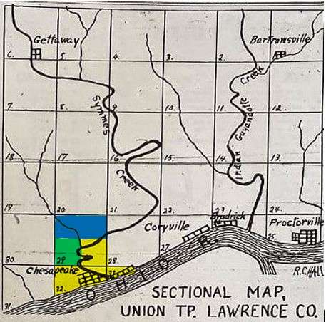
In the Union Township map, the highlighted area shows Edward Miller’s ownership, which includes today’s Village of Chesapeake and the property north of it, including the curve of Symmes Creek. [The other line on the map branching off the north area of Symmes Creek is now Buffalo Creek]. With James Gallaher giving up his rights to all the waterways, this sale gave Edward more control of the southern waterways of Symmes Creek.
1812 Edward Miller Purchases the SE Section 29
After winning his lawsuit against William and Elizabeth Miller, Edward Miller hired a land speculator to travel back to Chillicothe, Ohio, and purchase part of Section 29.
James Gallaher, a resident and large land owner from Cabell County, [W]Va., was now legally the Assignee for Edward Miller. Gallaher [sometimes spelled Galliher, etc.]. James purchased the South East Quarter of Section 29, Township 1, Range 16 at the Chillicothe Land Office on 20 April 1812.
In Gallia County, Ohio, Deed Book 6, pages 31-32, James transfers this property to Edward Miller on 29 May 1815, for $1,200.00. Getting this deed recorded in the Gallipolis Recorders Office took almost a year, with the final record being dated 5 March 1816.
The South East Quarter was northeast of the property that Miller owned in Section 33 and was bordered along Miller’s property. James Gallaher gave up his rights to “improvements, water course profits, and appurtenances, along with the real estate’s right and title interest in the property claims.”


Section 29 Has More Land Owners
 From the above Ledger, Edward Miller owns an additional 169.30 acres in the South East Quarter Section of 29. He deposited $84.64 on May 15, 1804, continued his payments in 1809 and 1810, and finally paid it in full on May 15, 1811.
Onto the above account on the same page of this Ledger was a John Smith of Gallia County, Ohio, who also purchased property in Section 29, Township 1, and Range 16. His purchase was for 169 acres in the North West Quarter. [blue section in map] This makes him neighbors with Edward Miller.
Smith’s first deposit was $84.50 on 7 Aug. 1816. On 26 Feb. 1825, he made his final payment for 84.50 acres and was issued a certificate on 23 May 1825. It is a bit disconcerting for me. Did Smith own 169 or 84.50 acres, or was it a combination of both amounts totaling 253.5 acres? Whichever is true, this was another battle Miller had to contend with later.
[In the last entry in this Ledger, Dr. Martin Frampton purchases property in Section 29. I will explain this entry later in this chapter].
Miller had purchased as much property as he could afford without using his Bounty Land Warrant from serving in the Revolutionary War. For those with a keen eye, did you notice anything confusing about the early Land Patents for Section 29? John Smith, Edward Miller, and Martin & Isaac Frampton were owners of the East Half and the North East Quarter in Section 29!! [Keep this important fact in mind as we travel on this journey with Edward Miller]
So what does all this mean, and more importantly, why am I adding this in “The History of Chesapeake, Ohio?” With these facts, you now know who the first landowners of Chesapeake were long before it was incorporated into a Village.
*In the above map of Union Township, the yellow part shows Edward Miller’s property, the blue is John Smith’s property, and the green is Martin & Isaac Frampton’s Land Patent from the Chillicothe Land Office.

1814 Edward Miller Sells 165 Acres in Section 32
In the Gallia County, Ohio, Deed Book 5, pages 291-292, Edward Miller sold 165.64 acres of his property in Union Township, Section 32, Township 1, and Range 16 to Christian Koontz for $497.00. Edward Miller and his wife Zabezah [sic – Rebecca] signed this deed Miller on 23 Nov. 1814, recorded in Gallipolis, Ohio, on 28 Nov. 1814.
Once Lawrence County, Ohio, was created from that portion of Gallia County, a correction was made on 23 Nov. 1816 in the Burlington, Ohio, Courthouse. It was found that Edward’s wife had incorrectly signed the deed*, which had to be corrected in Lawrence County, Ohio, Recorders Office in the Deed Book 4 and pages 210-214.
* In Lawrence County, Ohio, Recorders Office, she signed her name as Peggy Miller on 28 Dec. 1824, $497.00 for 165.64 acres. The deed wasn’t legally recorded until 30 April 1825.

1815 – Edward Miller Recorded His “Town of Washington” in Gallia County, Ohio, Deeds
We learn this crucial fact from the previous chapter, “Early Names of Chesapeake.” When Lawrence County, Ohio, became a county in 1818, one of the first entries in the Lawrence County, Ohio, Clerk of Courts Journal 1 & 2, page 10 was Edward Miller’s request that his “Town of Washington” be vacated, which the court granted.
1818 Lawrence County, Ohio, Becomes a County
Several things happened in Edward Miller’s life when the boundaries changed. He no longer lived in Gallia County, but his residence was now in Lawrence County, Ohio. First, he vacated his “Town of Washington,” and in the August Term of 1818, Edward brought his receipt into the Clerk of Courts in Burlington, Ohio, to keep his tavern at the “Mouth of Symmes Creek.”
The following year, on 2 Aug. 1819, Miller again went to the Clerk’s Office in Burlington and paid his annual fee for “His Tavern at His Stand” on the Ohio River at the “Mouth of Symmes Creek.” Having his tavern and ferry on Symmes Creek was undoubtedly Miller’s source of income, and it was essential for him to get his license as soon as possible.
1819 Edward Keeps His Tavern Business at "The Mouth of Symmes Creek"
| After Edward Miller sold his property to Christian Koontz [sic], one part he kept was his right to his tavern stand, which was on the “Mouth of Symmes Creek.” We know this from the following document in the Lawrence County, Ohio, Clerk of Courts, Journal 1 & 2, page 46, during the 2nd Day of the August Term in 1819. |

1820 was Lawrence County, Ohio, First Census
Since Lawrence County, Ohio, didn’t become a county until 22 December 1818, the 1820 Census was the first census taken. As shown below, Edward Miller lived in Union Township, Lawrence County, Ohio, in 1820. He had nine people living in his household when this census was taken. I noticed from this census page that no families live close to him with the Miller surname. However, several Miller families lived in Rome Township in the 1820 census.

1823 Lawrence County, Ohio Has a Large Riot, and Edward Miller and His Family are Charged by the State of Ohio
On 5 April 1823, Edward Miller’s second attempt to establish a town on his property was made when he recorded his “Town of Lawrenceburg” in Lawrence County, Ohio’s Deed Book 3, pages 225 & 284. Even though his “Town of Washington” failed and was vacated, he had one thing going for him – he owned the rights to the ferry at Symmes Creek. So with the confidence that he would finally have a town on his land, he had the land surveyed and lots lined out and proudly walked into the Burlington Courthouse with the necessary plat map and documents and recorded his new “Town of Lawrenceburg,”
Now, it is uncertain what exactly happened. [was Lawrenceburg the reason?] However, we know that as soon as the papers were recorded, the State of Ohio arrested Edward Miller. On 2 May 1823, less than a month after Edward, along with his family, was accused [and later convicted] of inciting a riot in Lawrence County, Ohio. We also learn from the Clerk of Court Journal 1 & 2, page 258, this was a large riot which included the following people:
- Edward Miller
- John Miller [Edward’s son?]
- Henry Miller [Edward’s son?]
- James Thomas [Edward’s son-in-law]
- John C. Shute
- George Koons
- Christopher Grant
- Henry Booth
- Phillip Koons
- George Stump
- John Davidson, Sr.
- Thomas Adkins
- William Davidson
Three months later, on 7 Aug. 1823, with his appeal pending, Edward Miller went to the Burlington, Ohio, Courthouse and requested his “Town of Lawrenceburg” be vacated. Three months after his request, on 6 Oct. 1823, the Court vacated Edward Miller’s dream of Lawrenceburg [just like the Town of Washington”].
While awaiting his appeal from the State of Ohio for “inciting a riot’, Edward was hit with another lawsuit on 7 Oct. 1823!! Was this lawsuit connected to the riot the Millers had “incited?”
1823 Edward Miller’s Neighbor John Smith Files a Lawsuit
The next day, after Edward’s town of Lawrenceburg was vacated by the Court, 7 Oct 1823, John Smith vs Edward, John and Henry Miller and James Thomas for Trespass by Force and Arms; Assault & Battery; Damages $500. This doesn’t require much explanation, but there are a few things to note in this lawsuit.
This was a massive fight with weapons and force. Edward’s family were strong, courageous men who carried arms and weren’t afraid to fight physically. Edward Miller was a former POW from the Revolutionary War who knew how to defend himself, and no doubt, this was taught to his sons as well.
Remember the map of Union Township where I highlighted Edward Miller and John Smith’s property in Section 29? Section 29 had Symmes Creek and the headwaters of Buffalo Creek. This was a prime location for water mills, ferry landings, taverns, and other means of profits. In the early surveys for Ohio, there was a lot of confusion about boundaries and landowners, resulting in numerous lawsuits for trespassing.
This case between Miller and Smith continued until 3 April 1824, when both parties agreed to settle at each other’s costs. Plaintiff John Smith was ordered to recover from the Defendants – [left blank] dollars and – [left blank] cents: Journal 1 & 2, pages 313 & 336, FamilySearch.org film #8198783.
Spoiler Alert: “When John Smith moved into Section 29, Edward’s legal problems began, and Miller got his revenge by selling all his property to the Framptons in 1827.”
1824 Edward Miller and Family Are Sentenced to Burlington Jail
For the next six months, everything was pretty standard for Edward; his tavern and ferry were bringing him a living, and he was hoping his appeal would be discharged. But on 3 April 1824, in his charge of the State of Ohio vs. Edward, John and Henry Miller and James Thomas were back in Court for their Appeal in the guilty verdict of the charge of ‘Indictment a Riot.’ After winning an appeal for the first jury trial, this would be their second jury trial where they were found “Guilty.”
With their unnamed attorneys, the defendants were again found guilty by a second jury. Their sentence was each defendant was ordered to be imprisoned in the common jail of Lawrence County for two minutes and was ordered to make a payment to the State of Ohio for 6 and 1/4 cents plus the costs of the prosecution. Journal 1 & 2, page 334, FamilySearch.org film #8198783

1824 Nine Prominent Men Found Not Guilty in Same Riot Charge
1824 3 April -The next case on the same day and page for the same offense, the State of Ohio vs. John C. Shute, George Koons, Christopher Grant, Henry Booth, Phillip Koons, George Stump, John Davidson, Sr., Thomas Adkins, and Wm. Davidson. For the “Indictment Riot,” they were all found not guilty. Journal 1 & 2, page 334, FamilySearch.org film #8198783
1824 Edward Begins Selling His Lawrence County, Ohio, Property
In researching Edward Miller and his family, I couldn’t help but notice that his family was repeatedly persecuted by the courts and other prominent men living in Lawrence County, Ohio. Was it because he had acquired such a large portion of prime real estate and was successful? Or could it be that his family was German?
This is not the first time I have seen this happen to other families that weren’t ‘rich and/or white’ in Lawrence County’s early records. Were his words incorrectly written because of a mistake in spelling and poor pronunciation? We know when Edward went before the Court to give his disposition for his pension, the Court brought in a German translator to read his family bible, which was written in German.
Whatever the reason, Edward Miller had enough of Lawrence County and the State of Ohio. On 13 Sep. 1824, he sold Isaac & Martin Frampton two parcels of land for $3,000. The first is in the Southeast Quarter in Section 29, Township 1, and Range 16 for 169 acres. The second parcel of land was in Section 33, Township 1, and Range 16 for “Indefinite” and Pt. 32 for 137 acres, which included his successful ferry license and his beloved tavern at “The Mouth of Symmes Creek.” Edward Miller and his wife Rebecca Miller signed the deed, recorded in Lawrence County, Ohio, Deed Book 4, pages 306-307.
Two months later, on 29 Dec. 1824, Edward Miller and his wife Peggy [sic] signed the corrected deed for 165 acres in Section 21 for property he sold to Christian Koontz in 1814. This was recorded in the Lawrence County, Ohio, Deed Book 4, page 210.
Edward Miller’s last entry for Lawrence County, Ohio, was on 12 April 1827, when he filed with the Chillicothe Land Office, giving his legal rights to the Frampton brothers, Martin and Isaac, for Section 29. Edward Miller was no longer living in Ohio and had permitted Martin Frampton to legally sell his land on his behalf, just as he had given James Gallaher to purchase his land years earlier.
This document made the Framptons, owners of one-half of the Eastern Section of 29 and the South West Quater of Section 29 on the Ohio River Survey, Certificate number 4222, why the Framptons needed Edward Miller’s help in purchasing this property through the Chillicothe Land Office is bewildering to me. The only reason I can come up with is Edward wanted to make one last mark on his enemy, John Smith.
The Frampton brothers, Martin and Isaac, own nearly all of Section 29, Township 1 in Range 16 in Union Township, Lawrence County, Ohio. After reviewing the land records, I found that the Framptons now owned most of the property covering sections 29, 32, and 33, currently Chesapeake, Rockwood, and North Huntington Heights.


1826 Edward Miller and His Family Moves to Indiana
With Lawrence County, Ohio, in his past, Edward Miller and his family moved “west” to Indiana in 1826. By this time, most of his children were married and had their own families, and like most, those children began to migrate.
Several Lawrence County, Ohio, residents moved to Shelby County, Indiana. After Edward Miller died, his widow, Rebecca, applied for her Widow’s Pension in Indiana. On 15 Nov. 1839, in the Probate Court, they were sworn in and stated they knew Edward, Rebecca Miller, and their children while living in Lawrence County, Ohio.
Those former residents were
- John Ellinger [Edward Miller, Sr. nephew]
- Royal Mayhew
- Edward Miller, Jr.
- Reuben Davidson [Edward, Sr. son-in-law]
- John Bumgardner [Edward, Sr. son-in-law]
- Isaac Miller [later said his name was Edward Miller, Jr.]
I have not researched the other children of Edward and Rebecca Miller [there were thirteen children in total]. I’m unsure where they all resided.
NOTE: In 1843, Alexander Miller was Justice of the Peace in Shelby County, Indiana. It is uncertain whether he was the son of Edward Miller, Sr., born on 19 May 1803.
1836 Jan 26 Edward Miller dies in Shelby County, Indiana
So here ends the life of Edward Miller, and I have a few words to say about this remarkable man. Many readers probably ask why I spent so much time researching his life.
Because Edward Miller’s name has never been associated with Chesapeake, Ohio, nor have I ever found mention of his importance in establishing Lawrence County, Ohio. He must be recognized as one of the most influential men in our local history.
He enlisted in the Revolutionary War from Augusta County, Virginia, 1779 and served in the second Virginia Detachment. He fought in one of the worst battles of that war and was taken and held captive by the British Forces onboard a boat in the Harbor of Charleston from 1780 until June 1781.
Edward Miller came to this country from Germany and fought for the United States against tyranny and for our freedom. He was intelligent, strong, and proud, refusing to accept his pension from the War Department until 1833. Why?
He stated in his disposition that he would not accept his pension as long as he could work. Finally, in 1833, at 79, Edward obtained his pension in Shelby County, Indiana, which entitled him to $80 per month during his natural life. He only received his pension for three years until his death on 26 Jan 1836.
To further document Edward Miller’s importance in Chesapeake’s History, compare his early maps of Washington and Lawrenceburg with the 1903 map of Lawrence City and the 1929 map of Chesapeake, Ohio.

1815 Map of the Town of Washington by Edward Miller

5 April 1823 Map of Lawrenceburg by Edward Miller

1903 Map of Lawrence City as Recorded in the Deeds

The Village of Chesapeake has had a few changes since this 1926 map was created. When they opened the new Robert C. Byrd Bridge, the boundary coming into Chesapeake from Huntington was shifted to the western portion of Chesapeake. [see photo below]

Photo Courtesy of the Facebook Group, “Vintage Chesapeake, Proctorville, South Point,” posted by Jason Sloan. Taken in 1994, this photo is of the old bridge built in 1926 and the new “Robert C. Byrd” bridge, taken from Huntington, WV.
Lawrence County, Ohio, was not ready for a man like Edward Miller, who saw the vision of Chesapeake as early as 1815. So the next time someone asks, “Who founded Chesapeake?” the correct answer is Edward Miller.
Love reading this. Very interesting. Looking to see more.
Harry Miller