
Click Below to View Township

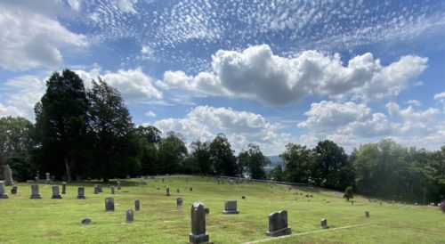 Union Hill Cemetery, Chesapeake, Ohio 2021
Photo Courtesy of The Lawrence Register Archives
The information from this list was taken from:
- The Recorder’s Office, Ironton, Ohio
- The Highway Map of Lawrence County, Ohio
- Personal knowledge of various persons
- Briggs Library Local History Room
- Lawrence County Genealogical Society
- And many road trips were taken by my brother, my son, and myself
If you find any mistakes in the following lists, or if you have any information about a cemetery not listed, please let me know in the comment section below. These cemeteries are listed by Townships, and please remember that in most browsers, you can search by pressing your “Ctrl + F” keys.
AID
SW 1/4 of SE 1/4, Section 25. 1 mi n of Aid, at jct of SR 141 & Symmes Creek. 1864, 3a.
ALDRIDGE
SW 1/4 of SW 1/4, Section 18. South of Aaron’s Creek Road, about 8/10, and east of jct of Aaron’s Creek Road and John’s Creek Road. The Joe Delawder Cemetery can be seen on a knoll to the south from Aarons Creek Road. From this knoll, a stand of Pine is visible at the head of a hollow to the south. Cemetery is shown on National Forest Map.
BARNETT
SW 1/4 of SW1/4, Section 21. Jct of Elkins Creek and Dean Hollow Road. On a hillside about 100 feet from Elkins Creek Road.
BLOOMFIELD
SE 1/4 of SW 1/4 Section 34. Take dead end road at jct of DeLoss & Sharps Creek Road. Go to the end of the road, cemetery is visible. About 100 feet uphill, to your right.
BOGGS
SE 1/4 of NW 1/4, Section 15. About mile south of Aaron’s Creek Road, back of John Turner’s. Follow the hollow to crest, highest point of land will be slightly east of center.
BOWMAN – DELAWDER
NE 1/4, of NE 1/4, Section 16. 4/10 mile east of road to McClure Lake and app. 250 yds off Aaron’s Creek Rd. The lane to the cemetery has a steep grade, can be traveled with four-wheeled drive. 4a.
BRADSHAW
NE 1/4 of SW 1/4, Section 12. About 200 yds from entrance gate on Elkins Creek Road. 2a.
BRADSHAW #2
SW 1/4, S17, T4, R177. Not far from Bradshaw Cem. Markers for small children.
CENTENARY U.M. CHURCH CEMETERY
SE 1/4 of SW 1/4, Section 5. On Johns Creek Road, jct with Slab Fork Road.
COLORED
SW 1/4 of NW 1/4, Section 30. Exact location unknown. Owned by Etna Furnace Co, in 1887, according to Hardesty Atlas.
CRANCE
SE 1/4 of SW 1/4, Section 31. At dead end road, south of Paddle Creek. App. 1/4 mile and 100 yds beyond first house on right. Branch of hollow on left, east side. Now Wayne National Forest.
DALTON
SW 1/4 of NE 1/4, Section 11. N side of CR16, part of Payton Cemetery.
DEAN
NE 1/4 of SW 1/4, Section 7. Take Schweickart Hollow Rd. from Johns Creek to now abandoned Schweickert. Go behind metal building next to house. There is a steep hillside covered with a pine grove. Follow ridge to the left, west about 150 yds to cemetery.
JOE DELAWDER
About center of NW 1/4 of Section 18. On the south side of Aarons Creek Rd (CR16). About 1/4 mile from jct of Aarons Creek & Johns Creek Roads. App. 200 yds on a knoll. Only a few markers.
DENNIN (NEAL)
NW 1/4 of SE 1/4, Section 4. From Arabia, go two miles west on Aaron’s Creek Rd to Gum Stump Rd, take road to top of hill. Take left fork app. 2/10 mile, cemetery is adj. To road on left, east side.
GATES
SW 1/4 of NE 1/4, Section 22. Elkins Creek Road, about 100 yds back of Raymond Fuller’s home, on his farm.
FERRELL, JOHN FARM
NW1/4, S20, T4, R17. West side of TR198, nr Rucker Cem.
GRIFFITH
NE1/4of NE 1/4, Section 3. From Gum Stump Rd, take Twp. 233 to strip mine. Road is destroyed at this point. You can see where it continues at top of the high wall. Go left to break in high wall. Climb steep back and road is in front of you. Go left to fork in road, which is jct with Twp. 197. Go right on CR197, about 200 yds. On left, woods about 75 feet from road.
GENNICK
NE1/4 of NW 1/4, Section17. Cemetery is on the hill side above the first house, east of jct of Aarons Creek and Five Forks Road. It is west of the ravine there, about 100 yds about 200 yds north of Aarons Creek. Only 3 markers.
HALL
SW1/4 of NE1/4, Section 5. Johns Creek Rd, about 100 yds n of Dolphus Arrington home, at edge of woods.
LAMBERT
SW1/4 of SW1/4, Section 12/ On Lena Jett farm, Aarons Creek Rd. Across rd from home about 50 yds back of the barn.
MYRTLE TREE
SE1/4 of SE 1/4, Section 1. About mile from Arabia and between Aarons Creek and Coffee Tea Creek roads.
NEAL, JOHN
NW 1/4 of NE 1/4, Section 17. South of Aarons Creek road on Don Willis’ farm. About 100 yds. Back of the barn, on a small flat at the edge of the woods. 1898. 1a.
NELSON
NE 1/4 of NW 1/4, Section 23 and SE 1/4 of SW1/4, Section 14, on back of a hill of Mr. McCartys home.
NIDA
NW1/4 of NW1/4, Section 23. App. 50 yds downstream and ab. 50′ from w bank of Symmes Creek, from jct of Symmes & Aaron Creek Rd.
OAKLAND CHAPEL
(Old White Oak Chapel) Section 32. Nr jct of CR5 & CR29. .6a.
PAYTON
NE1/4 of NW 1/4, Section 11. N sided of CR16.
RANKINS
SW 1/4 of Section 13 and the NW 1/4 of Section 24. From Symmes Creek Road, go about mile on Twp Rd 110. Road makes sharp curve to right. Cemetery is about 25 feet on right, at the top of the curve. .2a.
ROBINSON
SE1/4 of SW1/4, Section 4. Take Gum Stump Hollow Rd from Aarons Creek Road, to top of hill. Left fork is a dead end road, follow this road app. 3/4 mile to abandoned cement block building at which time it becomes a dirt lane. Cemetery on right side of dirt road, app. 100′ from building.
RUCKER
SW1/4 of SW1/4, Section 17, on west side of Five Forks Rd, about 3/4 mile south of Aarons Creek Rd.
RUSSELL
SE1/4, Section 27, next to Section 26 line. South of Sharps Creek Rd, about 50 yds and back of the barn on the Keith Mootz Farm.05a.
SOCKEL
SE1/4 of SW1/4, Section 32. On a point of land app. 125 yds south of Charles Payne home at jct of Oak Ridge & Paddle Creek Rd.
STEWART-WERNER
NE1/4 of SW1/4, Section 6. Follow old Twp Rd 140 NW, about a mile. Go to 1st rd w ab. 75 yds of Peter Worley home on Johns Creek. On left side of rd.
UNKNOWN
E side of NE1/4, Section 8. Johns Creek Rd. Take private rd on Peter Worley farm to crest of ridge. Go left, to line fence that is boundary of National Forest lands. Follow dirt rd to pipeline. Cemetery on E side of pipeline ab. 100 yds. south.
UNKNOWN
NW1/4 of SW1/4, Section 18. S Aarons Creek Rd, about 1/4 mile. From jct of Aarons Creek & Johns Creek Rd, the Joe Delawder Cemetery is visible. From that cemetery, a knoll in the same pasture is visible to S. To the right side of the knoll, there is a neck of the pasture field that extends toward the head of the hollow. The burial site is near the end of this piece of pasture.
UNKNOWN
SW1/4 of NW1/4, Section 20. App 75 yds W of Five Fork Rd, about midway between Rucker Cemetery and Kimble look out tower.
WALTERS
NW1/4 of SW1/4, Section18. Take farm rd at Don Delawder’s home app. 1/4 mile to a gate. App. 800′ from the gate is a large White Oak tree, about 30′ from the rd and on your right. It is on your left on the highest point of land and about 60′ from the rd is the cem. (CR16). 1862, .03a.
WILLIS?
SW1/4 of SE1/4, Section 19. Follow Paddle Creek Rd to jct of Paddle & Storms Creek. Turn right to dead end and to an area called Horse Park. Cemetery is ab. 250 yds S, up on a steep hill on the end of a finger ridge that overlooks the part. No road to cemetery. Now in National Forest.
VERMILLION
NW1/4 of SE1/4, Section 1. About 250 yds N of Myrtle Tree, at the end of a ridge that over looks Coffee Tea Creek & SR141. From where SR141 crosses Coffee Tea Creek, look W ab. 1/4 mile. Cemetery marked with huge wild cherry tree.
YATES
Near center of Section 8 and Twp Rd 196, exact location unknown.
YATES, Isaac
Center of north part of SE1/4, Section 17. About mile south of Aarons Creek. Follow the first hollow west of the pipeline to head. Look east along the ridge, a high knoll is visible, cemetery is on knoll.
BUCKHORN #1
Located across the highway (across a field, a creek, then up into the woods) from the old Buckhorn Furnace. .01a.
BUCKHORN #2
Location uncertain.
CAMP DEAN
Location uncertain, perhaps in Dean Forest Area. SE part of Twp, .3a.
COLLINS, EPH
NW1/4, S10, T3, R18. On W side of SR93, nr jct with CR41. .3a.
FINLEY
SE1/4, S9, T3, R18. CR41 (Buckhorn Hollow Rd).
KETTLE
NW1/4, S10, T3, R18. At Buckhorn Hollow Rd (CR41) and SR93. 1917. .92a.
LITTLE
SE1/4, S13, T3, R18. Macedonia Ridge, Buffalo Rd, Waterloo. Cemetery rd unmarked.
ROGERS
SW1/4, S21, T3, R18. Nr TR199.
THOMPSON
Location uncertain. Also a Thompson Cem. in Scioto Co. .2a. (R1, S36)
VERNON FURNACE
NW1/4, S22, T3, R18. Nr SR93, at Vernon. 1918. 1.18a.
WARNEKE
SE1/4?, S10, T3, R18. On TR207, nr jct SR93. Painter Hollow Rd, Pedro.
BAILEY
Section 1, White Oak Road.
BOWEN
NW1/4, S1, T2, R18. E of TR160.
BURGESS
S29, T2, R18. E of Pine Grove, across from St. Mary’s Church.
DALTON
Location uncertain.
DOLLARHIDE
Bottom of a hill, in the trees along the old railroad tracks of NW side of Pedro High School Rd. Section 21.
ETNA FURNACE
NW1/4, S22, T2, R18. Nr jct of SR93 and CR4. Behind Etna Mission Church. 1900. 5.6a
KELLY
Behind Rock Hill #3 Grade School. .02a
LAWRENCE
NE 1/4, S17, T2, R18. Nr jct of SR93 and SR522. 1877. 2.5a.
PEDRO
S22, T2, R18. On SR93 at Pedro. .03a.
PERRY
SE 1/4, S1, T2, R18. Nr CR4. Gone, under water tower, fence but no graves.
PINE GROVE FURNACE
S14 on Kelly’s Mill Road.
PINE GROVE LUTHERAN
S30, T2, R18. Location uncertain, presumed nr on Pine Grove on SR522.
PINE GROVE METHODIST
S30, T2, R13. E of Pine Grove on N side of CR26. 1883. 1.09a.
PUCKETT
NE 1/4, S?, T2, R18. W side of SR93. 2.27a.
ROYERSVILLE
NE 1/4, S29, T2, R18. CR26, Pinkerman Co. Road, Paddle Creek.
SILLIMAN
N of SR 654?, Little Pine Creek Road.
ST MARY’S CATHOLIC
S29, T2, R18. E of Pine Grove on North side of CR26.
STUMBAUGH (SHANNON)
14 on Kelly’s Mill Road.
TUNNEL
NW 1/4, S33, T2, R18. On TR179. .2a.
VESUVIUS
SW 1/4, S25, T2, R18. N side CR29, jct with L?? Rd. .59a.
ARTHUR
Location uncertain. 1898. .08a.
BURLINGTON GREENLAWN
S2, T1, R17. US52. 1900. 1.08a
BURLINGTON 37
Across from Wal-Mart Shopping center. Also known as TOMS Cemetery.
CRAWFORD FAMILY
On Ohio River, next to Sybene Airport.
DAVIDSON
Location uncertain. Divica (Dicidel?) St. .17a.
DAVIDSON – McKEE
Location uncertain. On US52. .07a.
FREEWILL
About 3 miles up Charley Creek Road, on right side of road. Section 23.
HAWES
Lick Creek Rd. WPA. .04a.
HIGHLAND MEMORIAL GARDENS
Off US52 . Section 29.
LEBANON
Section 10, off Rankins Creek Rd. 1869. .49a.
LYND
NE S22, T1?, R17. Location uncertain. .09a.
MACEDONIA
S25-26, T1, R17. About 3 miles up Charley Creek Road on right side of road. 1898. 1a.
MADDY
S3, T1, R17. CR55.
MOORE
Off Rankins Creek Rd, close to Lebanon Cem. 1862. .5a.
OAK VIEW
Location uncertain. .03a.
SYBENE
S36, T1, R17. US52. .52a.
THOMPSON
Location uncertain. Rankins Creek Rd. CR17. .1a.
TOMS FAMILY
Across from Wal-Mart Shopping Center. Now known as Burlington 37 Cemetery.
WHITE COTTAGE
Off Solida Road, Old 52 in “S” curve before getting to Old Farms Subdivision. 1877. 1.41a.
AUSTIN
S52. .04a.
BUMGARNER
US52. .1a.
COLLINS
US52. .11a.
DAVISSON – GILRUTH
US52. 1862. 4a.
HANGING ROCK
SW1/4, S7, T1, R18. W side of SR650, near Hanging Rock. 1862. 4a.
JENKINS
US52. .1a.
McKEE
US52. .04a.
TRUMBO
Location uncertain. Probably same as George Trubo Cem. .1a.
YINGLING
SW1/4, S10, T1, R19. Location uncertain. Probably nr CR128.
BALD KNOB
MW 1/4, S11, T2, R17. TR112, nr jct CR6. 1892. .6a
BLAIR
SW1/4, S8, T3, R17. CR105, Homeless Road.
BRACE
Located on the hill side behind 3664 Co. Rd. 6 Kitts Hill, Ohio. That is about half way between Rock Camp and Andis Ohio. Coming from the Deering end of Co. Rd, 6 it is on the left side of the road. It sets in behind that new log house that has been build in the last two or three years.
Submitted by Everett D. Jenkins and (Gloria)
BROWN
One Drift Rd, CR61. 1935. .5a. Location uncertain.
CORBIN
S23?, CR61 and TR. 1908. 3.57 a
DRIFT CREEK
Location uncertain. .19a.
FRADD (FRAUD)
NW1/4, S4, T3, R17. Nr jct of CR19 & CR105 (Circular shaped). .08a.
GORE
SR141? 1860. .1a.
HACKWORTH
SW1/4, S20, T3, R17. TR145, nr jct TR274. 1860. .1a.
JENKINS #1
SR141? 1857. .1a.
JENKINS #2
Location uncertain. 1880. .1a.
KITTS
NW1/4, S17, T3, R17. Nr jct CR53 and SR141. .1a.
LEACH
S1/2, S3, T3, R17. Nr SR141, south of TR116.
LEATHERWOOD
NE1/4, S34, T3, R17. Nr TR249. 1869. .9a.
LODGE RIDGE
NW1/4, S3, T3, R17. TR116. .8a.
LOW
Location uncertain. 1865. .1a.
MAMRE #1
NW1/4, S17, T3, R17. SR141. 1886. 1a
MAMRE #2
NW1/4, S17, T3, R17. On SR141, near MAMRE #1. .55a.
MAYS
SW1/4, S21, T3, R17. CR53 (Ned’s Fork Rd.). 1906. .4a.
MYRTLE RIDGE BAPTIST
S14-23, T3, R17. CR61 (Drift Creek Rd). 1887. 1a.
PINE GROVE
Location uncertain. 1865. 2.11a.
POSTEN
Location uncertain. 1878. .2a.
ROSS
SE1/4, S14, T3, R17. On TR247, nr jct SR217. .44a.
WEBB
SE1/4, S17, T3, R17. CR53 (Ned’s Fork Rd.)
WILLIAMS
SE1/4, S27, T3, R17. TR249 at Leatherwood Creek Rd. 1882. .25a.
WILLIS
NW1/4, S36, T3, R17. Leatherwood Creek Rd.
ALLEN
South of TR204. .07a. Location uncertain.
ASH
Location uncertain. .02a.
BAPTIST, OLD – MT. PLEASANT BAPTIST
NE1/4, S16, T3, R16. CR2, nr jct with SR775. 1863. .9a.
BOSTIC
TR204. .04a.
BRUMFIELD – RUNYONS
SE1/4, S3, T3, R16. SR775. 1898. .13a.
CALLICOAT
SE1/4, S34, T3, R16. TR122, close to Windsor Twp line. .05a.
CHRISTIAN CHAPEL
Location uncertain. 1894.
CHURCH OF CHRIST
Location uncertain. 1908. 2/3a.
ESTEP
SR141. 1919. .5a.
FAIRVIEW BAPTIST
NW1/4, S20, T3, R16. SR141. 1871. 1.9a.
HASKINS
S14, T3, R16. TR217.
KERNS
CR2. .5a.
KINGERY
Location uncertain. .04a.
LAWRENCE CHAPEL
NE1/4, S26, T3, R16. CR63. 1865. 1.0a.
LOCUST GROVE M.E.
The Locust Grove (Methodist Episcopal Church) Cemetery is on Greasy Ridge Road (Lawrence County 2), in Mason Township. The cemetery is 1/4 mile north of the Greasy Ridge Road intersection with Ohio 775, about 14 miles north of Proctorville and 2 miles south of Wilgus. The cemetery is active, well maintained, and fenced. A brick gate fronts on Greasy Ridge Road. A gravel road runs parallel to the cemetery and provides access to the oldest graves.(Thanks to Philip B. Holmes for this update)
MT. HERMON
CR62?. 1891. .11a.
NEW ZION
SW1/4, S27, T3, R15. Nr jct of CR2 & TR ?. 1874. .9a.
OKEY
S11, T3, R16. CR37.
RAPP
S22, T3, R16. CR2.
ROBINSON
Location uncertain. Buckeye Road? 1865. .4a.
ROSE
NW1/4, S23, T3, R16. CR213.
RUCKER
NW1/4, S22, T3, R16. CR2.
SANFORD CHAPEL
Location uncertain. .5a.
SAUNDERS
S12, T3, R16. TR167. .08a.
SAUNDERS POINT
Possibly same as Saunders Cemetery. S12, T3, R16. 1860. .04a.
UNITED BAPTIST – PALESTINE CHURCH?
S14?. 1860. .04a.
WHITROCK
Location uncertain. CR13. .01a.
ALLEN #1
S33, T3, R17. TR249. 1865. .31a.
ALLEN #2
1909. .09a.
BAKER
Location uncertain. 1915. .11a
BAZELL
S28, T2, R17. CR52. 1899. .21a.
BRAMMER
S33, T2, R17.
BROHUMMELL
S28, T2, R17. Location uncertain, but nr CR6.
BRUBAKER
mi N of US 52. .08a.
BRUCE
SR243. .01a.
CHATFIELD
Location uncertain. .12a.
COMMUNITY
SR 243, on Community Cem. Dr., turn right after Warren Hill.
CRABTREE
Location uncertain. .12a.
CURRINGTON
S28, T3, R17. CR52 nr CR6.
DEARFIELD
Location uncertain. .06a.
FIELDS
NE1/4, S32, T3, R17. CR6.
HAMMOND
Location uncertain.
HOLLEY
S4, T2, R17. Nr CR55.
ICE CREEK
S4, T2, R17. Nr CR55.
KELLEY
Location uncertain. .18a.
KEYS
TURN RIGHT OFF OF 266 AT CREST OF HILL PRIVATE DRIVE UP HILL Parcel 14-049-1702. Legal description is: Range 17, Township # 3, Section 33, N.E. This cemetery is located in the front yard of Henry (Bo) and Darlene Elliott address is 832 Township Road 266, Kitts Hill, (Rock Camp).
MARTIN
Location uncertain. 1894. .12a.
MELVIN
SE1/4, S32, T3, R17. Location uncertain, nr CR6.
ROWE
Location uncertain. .11a.
SOUTH POINT
Nr CR52, could be in another township.
WALLER
Location uncertain. 1876. .14a.
WINTERS
Location uncertain. .03a.
BOSTER
Location uncertain. .6a.
BEULAH BAPTIST
S22, T1, R13. SR243 & SR7. .55a.
COYLE
CR2? .15a.
FULLER
Near Roman Harbour Subdivision. .18a.
GUTRIE (GUTHRIE)
On SR7, where? .04a.
GUYAN VALLEY
S15, T2, R15. SR217, nr jct SR218. 1.32a.
JOHNSON FAMILY
Location uncertain.
JONES
CR12? 1917. .5a.
LEWIS – NULL
Location uncertain.
LOVE
Location uncertain. 1897. .12a.
MILLER
S15, T2, R15. SR217 nr jct SR7. 1865. 2.82a.
NULL
Location uncertain. 1908. .18a.
PLEASANT RIDGE CHURCH
S33, T2, R15. Nr jct CR12 & CR67. ,9a.
ROME METHODIST – ROME OLD
S28, T1, R15. At Rome, SR243. 1869. 3.45a.
SWAIN
SR7.
WEBB
Location uncertain. .06a.
WHITE – LEWIS
Location uncertain. 1918. .29a.
WOLF CREEK
Location uncertain, nr CR66? 1904. .06a.
BUFFALO – REHOBETH
NE1/4, S15, T5, R17. CR4. 1871. 3.7a.
BURK
S35, Handley Br. Rd.
CAULEY
S10, T5, R17. Nr Cauley Cr Rd (CR46).
COOPER
NE1/4, S35, T5, R17. Nr jct CR60 & CR4.
DENIN
SR196, from Aaron’s Creek.
FLETCHER – THOMPSON
SW1/4, S3, T5, R17. TR188. .004a.
IRVIN
S36, T5, R17. N side of CR4.
MACEDONIA
NE1/4, S19, T5, R17. North of jct CR14 & CR47. .82a.
MILLER #1
S24-25, T5, R17. Nr Gallia County line, cr CR14 & SR141. .14a.
MILLER #2
Location uncertain. 1889. .5a.
PALESTINE – STEWART
NE1/4, S33, T5, R17. On CR49. 1862. .43a.
ROBINSON FAMILY
At the top of a hill at crossroads, turn left.
SYMMES VALLEY
Location uncertain. Twp Clerk does not know of this cemetery. .44a.
THOMPSON
Location uncertain.
WISEMAN
NW1/4, S35, T5, R17. On TR267 nr jct CR4. 1865. .44a
WICKLINE
NW 1/4, S35, T5, R17. N side of CR4
YATES
SW16-17, T5, R17. N side of CR14.
BLACK
SR 775.
BOOTH
Location uncertain.
BRADRICK CEMETERY
Location uncertain. Adj. to Low Gap Cemetery?
BRAMMER
Location uncertain.
CHESAPEAKE MEMORIAL
North Huntington Heights.
CLEMENT FAMILY
Location uncertain.
EARLES
From Chesapeake, follow Rt. 7 to Braderick, turn left at the Signal Light. From Bradrick, follow Rt 243 several miles to Getaway, at Stop sign at Collins Technical Center continue straight (Rt 243 turns left) on Rt 278 several miles until you see Symmes Creek Baptist Church on the right, set back about 1/4 mile from the highway. Turn right on road toward the Church. Go past the church and up the hill behind the church. 1/2 to 3/4 way up the hill on the right is the cemetery. It is unmarked and in poor condition. No maintence has been done in quite a long time.
It is hard to see but has one or two tall headstones that you should be able to see. (Of Bennett Earls) SOURCE: findagrave.com
FAULKNER
S22, T1, R16, CR68, 1 mi S of SR243. 1859. .3a.
FERRIS
off SR243 (Joe Woodard).
GETAWAY – HARMONY BAPTIST CHURCH
SE1/4, S6, T1, R16. At Getaway, jct SR243 & SR378. 1872. .71a. Two cemeteries are there.
GOODALL #1
S3, T1, R16. CR2. 1882. .25a.
GOODALL #2
CR115 (Bear Creek Rd).
KERR
15086 SR 243 Property of Andrew Shaffer about 3 milieus SE of Getaway Church
LANGDON
NW1/4, S6, T1, R16. Nr jct SR243 & SR 378, NW of Getaway. 1903. 1.75a
LOW GAP
SR243, at the top of Bradrick Hill, turn right on Browning Rd, next to church on left. 1897. .92a.
McCORMICK
SR775. 1861. .7a.
MT. PISGAH
SR775, next to church across the road.
RILEY
RILEY# 2
SR 775. 1900. .07a.
SPENCER METHODIST
Nr jct SR243 & SR378? 1900. 1.77a.
SUITER #1
S27, T1, R16. Left side of road, across from Bradrick Mini-Mart, off SR243, from SR7. On top of steep hill, overlooking Ohio River & Huntington, WV.
SUITER #2
S27, T1, R16. Next to Suiter #1.
TABOR
SR243. 1911. .54a.
UNION BAPTIST
S12, T1, R16. Nr SR775? 1904. .88a.
UNION CHAPEL
NW1/4, S12, T1, R16. TR186 nr jct SR775. .28a.
UNION HILL
Tallow Ridge Rd, Chesapeake.
CALVARY
Lorain Street, off Woodland Cemetery, Ironton/Coal Grove exit. 1867. .1a.
HECLA
NW1/4, S14, T1, R18. SR141. 1876. 3a.
HENRY
SE1/4, S17, T1, R18. N side of US52. 1863. 1.2a.
KELLY
SW1/4, S21, T1, R18. Nr jct of US52 & SR141 (Boneyard Hollow). 1863. 1.2a.
LAGRANGE
S9, T1, CR21. 1885. 1.5a.
NEWTON
Across from Coal Grove Fire Station, Lorain St, Ironton OH. 1869. 2.86a.
PIGEON HOLLOW
S8, T1, R18. Nr TR151.
SACRED HEART
S15-16, T1, R18. Turn right on the road across from Hills Dept. Store, Ironton, Ohio. (Coryville Rd.) Go about 1.5 miles, cemetery is on right side of road. 3a.
SUGAR CREEK
S13-14, T1, R18. On SR141 at jct Sugarcreek Rd. 1898. 2a.
WOODLAND
Lorain Street. Or turn off the Coal Grove Exit from US52 West, turn right at stop sign and left at first road on left, turn right at Shawnee Mental Health Center, then left into the chain link fence. 1871. 50a.
ZOAR
S31-32, T1, R18. Just off N side of SR243. 1841?? 4a.
OLIVE FURNACE – MT OLIVE?
S35, T4, R18. SR93.
UNION BAPTIST
Near Blackfork. 1915. 1.28a.
UNNAMED
S24, T4, R18. Location uncertain
UNNAMED
S28, T4, R18. Location uncertain.
WASHINGTON, OLD
SR93??
BRAMMER
NW1/4, S33, T2, R16. CR36, McKinney Creek Rd, 2 mi N of SR243. .71a
BOWEN
Between Hell Creek & Reeves Creek.
BURCHAM
Location uncertain.
CENTENARY
NW1/4, S21, T2, R16. CR2, two parts, on opposite sided of road, about 1.47a combined. 1864.
COX
CR2, Greasy Ridge Road. .01a.
DILLON
NE1/4, S4, T2, R16. SR775. 1887. .47a.
FAULKNER
In Windsor Twp. Cemetery Book by John Jones and in DAR notebooks it is listed as in Union Twp. 1902. .11a.
FORBUSH
Location uncertain. .12a.
FORGEY
SE1/4, S35, T2, R16. SR775. 1864. .91a.
GERMAN
SR217. 1.09a.
HARVEY
NW1/4, S12, T2, R16. Nr CR37.
KINGERY
NE1/4, S3, T2, R16. Nr TR225. 1865. .48a.
LEMLEY
Location uncertain. SR775. 1870 .04a.
LINVILLE
Location uncertain.
LUTHERAN
Location uncertain.
MANN
On line bet S22 & S23. .12a.
MANNON
Location uncertain. 1840. .04a.
MURNAHAN
SE1/4, S7, T2, R16. Nr SR378. .04a.
NEW ZION
Location uncertain.
PERKINS RIDGE
Center of S9, T2, R16. CR2 N of Dobbstowns. Old part. .58a.
New part, 1873. 1.7a.
PINE GROVE
NW1/4, S35, T2, R16. CR65, Slate Run Rd, mi S of Ceebee. .37a.
PINKERMAN
Loaction uncertain. 1903. .12a.
POLKADOTTE see also Sowards
The cemetery is located on the south side of Polkadotte Platform Road N (Township Road 80 N) about 0.7 miles east of its junction with Scottown-Lecta Road (County Road 37). The cemetery is located in Windsor Township, Lawrence County, Ohio, and is # 6603 (Sowards Cemetery / Polkadotte Cemetery) in “Ohio Cemeteries 1803-2003”, compiled by the Ohio Genealogical Society.
POMARIA
SE1/4, S33, T2, R16. CR2, Greasy Ridge Road, off Bear Creek. .3a.
SCOTTOWN
Proceed out of Scottown NE on Rte 217 for about 1.5 miles. At a sharp right turn with the stately ‘old John Fulks farmhouse’ on the left and a grain silo immediately across the road on the right, turn left off Rte 217 and proceed NW up a rough, steep township road labeled, T-81, on the Lawrence Co. map. T-81 commences immediately to north of the Fulks farmhouse. Once on T-81, take all junctions to the left, through couple of fenced pastures to the end of the road and the cemetery. The distance is approximately 1 to 1.5 miles from Rte 217. On a Lawrence County map, the site is located near the middle of the boundary of Windsor Twp Sections 12 and 13. [Thanks to Henry S. Dillon for sending us these directions! – mk]
SINGER
Location uncertain. 1907. .33a.
SOWARDS see also Polkadotte
The cemetery is located on the south side of Polkadotte Platform Road N (Township Road 80 N) about 0.7 miles east of its junction with Scottown-Lecta Road (County Road 37). The cemetery is located in Windsor Township, Lawrence County, Ohio, and is # 6603 (Sowards Cemetery / Polkadotte Cemetery) in “Ohio Cemeteries 1803-2003”, compiled by the Ohio Genealogical Society.
The cemetery is located on the south side of Polkadotte Platform Road N (Township Road 80 N) about 0.7 miles east of its junction with Scottown-Lecta Road (County Road 37). The cemetery is located in Windsor Township, Lawrence County, Ohio, and is # 6603 (Sowards Cemetery / Polkadotte Cemetery) in “Ohio Cemeteries 1803-2003”, compiled by the Ohio Genealogical Society.
The cemetery is located on the south side of Polkadotte Platform Road N (Township Road 80 N) about 0.7 miles east of its junction with Scottown-Lecta Road (County Road 37). The cemetery is located in Windsor Township, Lawrence County, Ohio, and is # 6603 (Sowards Cemetery / Polkadotte Cemetery) in “Ohio Cemeteries 1803-2003”, compiled by the Ohio Genealogical Society.
WAKEFIELD
Off SR775, on left on hill behind a mobile home, across from Love Farm. 1888. .12a.
WILSON
SR217. .13a.
WINDSOR M.E.
Location uncertain. 1856. .9a.
ZIMMERMAN
NW1/4, S2, T2, R16. S of TR122. 1876. .07a.
0 Comments