
The Early History of Chesapeake, Ohio
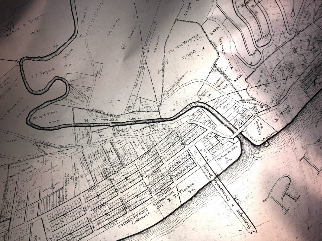 Welcome to an online book that explores the village’s roots. Incorporated in 1907, Chesapeake is one of the newest villages in Lawrence County, Ohio. For more than thirty years, I researched how the village came to be, who helped establish it, and why. Along the way, I uncovered some of this community’s lost history and learned about the people who lived through its hardships, disappointments, tragedies, and triumphs.
Chesapeake grew out of several smaller communities. I focus on Frampton, Lawrence City, Rockwood, Kounston, and North Huntington, later known as North Huntington Heights. I also look at proposed towns, such as Washington, that were never established.
Nearby settlements included Sybene, Bradrick, Coryville, Getaway, Bartramsville, and Quaker Bottom. I touch briefly on the role these settlements played in Chesapeake’s development.
The chapters trace the history of the early communities and show how they eventually came together as the village of Chesapeake. I hope you enjoy discovering Chesapeake’s history as much as I have over the years.
Chapters
Union Township Early History
Chapter I
Early Names of Chesapeake
Chapter II
Edward Miller
Chapter III
Lawrenceburg
Chapter IV
Kounston
Chapter V
Frampton Ferry
Chapter VI
Rockwood
Chapter VII
Lawrence City
Chapter VIII
Chesapeake Becomes a Village
Chapter IX
Explore Our Archives
Recent Articles
Did you know?
The 1926 map shown in the introduction illustrates how the Ohio River and Symmes Creek shaped the ultimate layout of Chesapeake, Ohio. Lawrence City was west of Symmes Creek and included the small area known as Kounston. Rockwood was east of the creek and included the small area known as Frampton. North Huntington Heights lay to the north.
Acknowledgments
I owe a lot of people gratitude for supplying photos, stories, newspaper clippings, and much more. All images I have used in this book will be given the common courtesy of giving credit to where I found them and with the owner’s permission, when possible. If any photo included doesn’t have the proper ownership, don’t hesitate to contact me so I can rectify any mistakes or misunderstandings.
I want to thank David and Joyce Hager, who rekindled my enthusiasm to write and finish this book. The moment they allowed me to take home the scrapbook, filled with Chesapeake history, I knew I had to finish it. Along with the maps David and Joyce allowed me to copy and use for this book, I want to say personally, “Thank You!”
My most significant contributor to helping me with my research, taking photos, and just listening to me talk about the history of Chesapeake is my son, ‘Matt’ Bice. I couldn’t have finished this project without his constant help. “Thank you, Matt!” And lastly, “Thank You” goes to my daughter and son-in-law, Sara and Earl Strohmeyer, for their encouragement, proofing, and editing of this book and other stories on the Lawrence Register.
I hope you enjoy reading this book as much as I enjoyed collecting photos, reading stories, researching old documents, and listening to older residents.
Note on Sources
Like many history books, you may have some discrepancies in stories, dates, names, and places. Verifying evidence in the 19th and the early 20th Century is sometimes tricky. But, with great confidence, I have done my due diligence to prove the facts published in this book.
Copyright and Reprint Permissions
Please contact me if you have any questions or want express permission to use any portion of this book, which is fully copyrighted by Martha J. Martin (Kounse) for The Lawrence Register website at www.lawrencecountyohio.com.