The areas once known as Lawrenceburg and Kounston merged into “Lawrence City.”
Chapter Eight
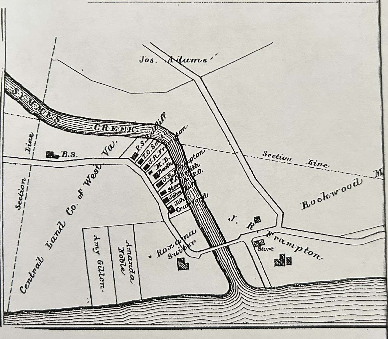
While Rockwood flourished, another small community steadily developed on the other side of Symmes Creek. The area once known as Lawrenceburg and Kounston became identified as the Central Land Company of West Virginia; afterward, it was briefly called “Lawrence City.”
1887 Hardesty Atlas, showing the land west of Symmes Creek owned by the Central Land Company of WV.
Central Land Company of West Virginia
C. P. Huntington, the Chesapeake & Ohio Railroad president, traveled to this area in 1869 and saw the potential for a new terminus for his railroad. He bought property along the banks of the Ohio River in both West Virginia and Ohio, which included Chesapeake, Ohio. One of those transactions was from Asa and Julia Kimball, who sold 497.8 acres to Huntington on 14 March 1870 for $25,000.[1]
He then transferred his land to a new company, The Central Land Company of West Virginia, chartered in 1871, the same year the new city of Huntington, WV, was incorporated. The leaders in this enterprise were C. P. Huntington, Fisk & Hatch, Wm. H. Aspinwall, Pliny Fisk, and other well-known capitalists.[2] D. W. Emmons was the General Superintendent, John H. Oley was an Agent, and James J. Tracy was the Secretary and Treasurer, having their principal office at 55 William Street, New York.[3]
Soon after the Central Land Company of West Virginia was established, ads began running in the local Huntington, WV, newspapers announcing an extensive frontage of land running nearly four miles on the Ohio River. This land claimed to have been carefully surveyed, and a large part of it was lots suitable for residences, manufacturing, mercantile, and other business purposes.
The main advantage of this land was that it was located at the head of reliable navigation along the Guyandotte River, Indian Guyan, Symmes Creek, and the Ohio River. C. P. Huntington planned to have the western terminus of the Chesapeake & Ohio Railroad, connecting Huntington, West Virginia, to Richmond, Virginia, and the promise of additional terminals of six or seven additional railroads, connecting C&O Railroad with each one.
The railroad arrived and brought immense growth. Large manufacturing companies were built, including a large car factory and a car wheel foundry, which expanded to the Big Sandy River, where it met Kentucky. Soon, other connectors were added from the east, such as Parkersburg, B&O, Pittsburg, and Cincinnati.[4]
As C. P. Huntington proudly watched his gigantic railroad develop, he soon realized he could obtain more control if he could connect the town of Huntington with “the entire West and the Northwest.” To achieve this, he had to build a railroad bridge crossing the Ohio River at the mouth of Symmes Creek, going north to the major cities.
He and his associates wrote many letters to newspapers, boasting about his industry associated with the railway, including the company’s principal machine, manufacturing, and repair shops. In those letters, he also told of his plans to build the railroad bridge. As soon as that news spread, so did the opposition and rumors.
C. P. Huntington grew arrogant and told his adversaries that his bridge would undoubtedly be built no matter what. However, he did not foresee the financial collapse of 1873, and soon afterward, most of Central Land Company’s investors quickly sold their interests to other investors. Interestingly, the Company’s building was burned to the ground in March 1875 but was insured for $25,000.[5]
The Central Land Company was owned by a Board of Directors, one of whom was B. W. Foster. After years of struggles with various lawsuits,[6] the company entered receivership in 1890.
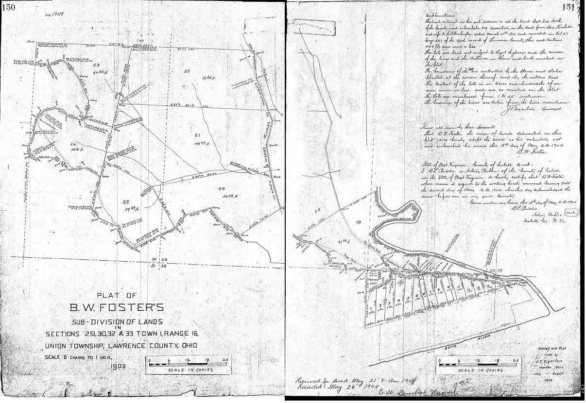
After C. P. Huntington’s sudden death on 13 August 1900, Foster became the landowner of the area northwest of Lawrence City. Two years later, he recorded his survey map with the Recorder’s Office and began selling lots in “B. W. Foster’s Subdivision.” Foster successfully sold his property and later became a significant owner of hardware businesses in Huntington, WV. Some of Foster’s property is now Plantation Heights on Big Branch Road.[7]
[1] Lawrence County, Ohio Deed Book 27, pages 447-449.
[2] The Wheeling Daily Register, 10 June 1871.
[3] Huntington Argus, 1 Jun 1872.
[4] The Catholic News Archive, 6 June 1891.
[5] Evening Post, 30 March 1875.
[6] John B. Landley vs. Central Land Company, filed in April 1882, lingered until March 1900 after C.P. Huntington filed an appeal. C. P. Huntington died suddenly on 13 August 1900.
[7] Plat Book 5, pages 280-282, dated 24 April 1963.
1902 Plat Book 2, pages 150-151, showing B. W. Foster’s subdivision, now part of Plantation Heights on Big Branch Road, Chesapeake, Ohio.
Lawrence City 1903
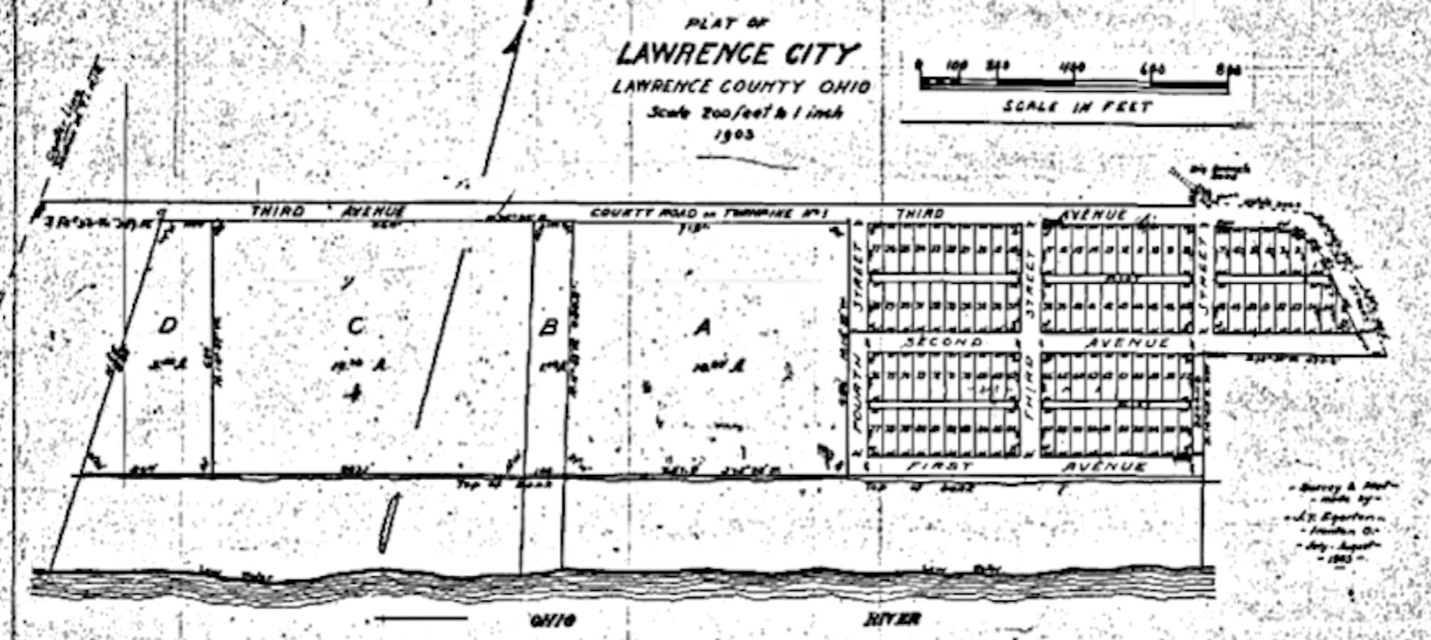
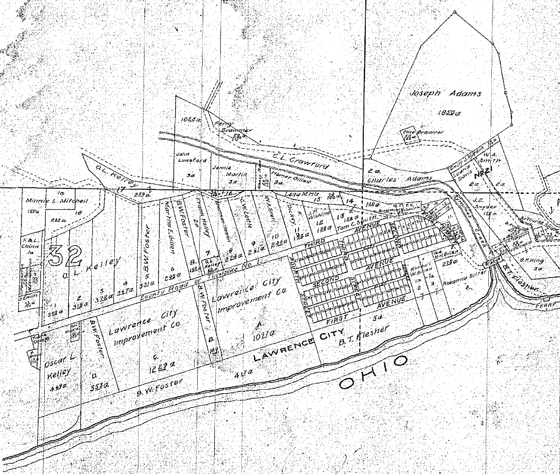
The first plat map of Lawrence City, dated 1903, shows it was already divided and surveyed. Andrew P. Kouns had divided some of his property into parcels and named them Lots “A,” “B,” and “C” before trying to form this area into his beloved town of Kounston. The area east of Lot “A” had already been surveyed by Edward Miller’s early attempt to create the towns of Washington and Lawrenceburg without success. The comparison of the two maps is below.
Lawrence County, Ohio, Recorder’s Office, Plat Book 2, page 152, 1903.
Recorded in 1903 at the Lawrence County, Ohio, Recorder’s Office Plat Book 2, page 172.
The Legal Description of the Lawrence City is in Plat Book 2, Page 152, Typed As Follows:
Streets and Avenues:
- First Avenue is fifty feet wide and extends from Second Street to Fourth Street.
- Second Avenue extends from First Street to Fourth Street and is fifty feet wide from Second Street to Fourth Street. And from First Street to Second Street, its North line is in the same line as from Second Street to Fourth, and the South line is the boundary line of the property and is fifty feet at the center of Second Street and is sixty-one and seven-tenths feet wide more or less on the west line of the First Street.
Third Avenue:
- The County Road on Turnpike No. 1 is called Third Avenue and extends from the center line of Section 32 Township 1 Range 16 to the corner of lots two and three and is 42.9 feet wide measured on center Section line and is fifty feet wide from the Northwest corner of Lot “D” to the Northeast corner of Lot “S” and from lot eight to corner of lots two and three.
- The front line of the lots is laid twenty-five feet from the center of the present traveled road or Turnpike No. 1.
First Street:
- The County Road or Turnpike No. 1 from the corner of lots 2 & 3 to the property’s boundary line or the South line of Second Avenue is called First [Street]. The lot lines are twenty-five feet from the center of the present traveled road, or Turnpike No. 1, and all the land to the property’s boundary line (said line being in said road or Turnpike) is included in said First Street.
J. T. Egerton, Surveyor
July to August 1903
Lawrence City Improvement Company
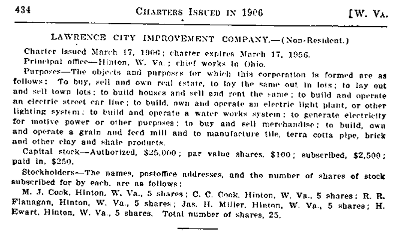
Three years later, on 17 March 1906, five ambitious men from Hinton, WV, formed the Lawrence City Improvement Company.[1] M. J. Cook, C. C. Cook, R. R. Flanagan, Jas. H. Miller, and H. Ewart saw immense opportunities to work in Ohio.
Their primary purpose was to buy and sell real estate, lay out and sell lots, build homes to sell or rent, build and operate an electric streetcar line, build, own, and operate an electric light plant, build and operate a waterworks system, provide electricity, buy and sell merchandise, build, own, and operate a grain and feed mill, and manufacture tile, terra cotta pipe, bricks, and other clay and shale products.
[1] There is a discrepancy in the name of this corporation: it was chartered as ‘The Lawrence City Improvement,’ but some sources called it ‘The Lawrence County Improvement.’
West Virginia’s Secretary of State’s Corporation Report 1905-1907.
A newspaper from Hinton, WV,[1] went into more detail: Hinton Parties on Ground Floor – Hold Valuable Tract of Land Opposite Huntington Which Has Been Laid off in Lots – The Secretary of State issued this week the following charter:
Lawrence County Improvement Company[2], Hinton. To deal in real estate Capital stock, $25,000; incorporators, M. J. Cook, C. C. Cook, R. R. Flanagan, James H. Miller, and H. Ewart of Hinton.
The Huntington Herald, speaking of the deal, says, “This looks simple, but it is the keystone of an important story that means much to this city.
Will it operate at Hinton? No. This company purchased sixty acres of land in Lawrence County, Ohio, just across the river from the foot of Second Street [Huntington, WV], close to the proposed bridge terminal.
James H. Miller was a prominent Democratic politician who was once a candidate for Congress in the Third District. He received a private tip from New York that the Ohio [River] would be bridged in this city. He and his associates quietly purchased sixty acres of land, even before the people of Huntington [West Virginia] knew about the bridge plans and before the engineer corps was placed to work on Symmes Creek.
Real estate in Huntington, [West Virginia], will be in four months [sic] more valuable than any city on the Ohio [River], as the bridge is an assured fact. If the C&O and the Deepwater Tidewater Road[3] keep up their fighting, as has been going on along their routes in Raleigh and Wyoming counties, there may be two bridges here. If not, Huntington [West Virginia] will, in the coming summer, see the grapple of two of the most powerful corporations in the world, Pennsylvania and Standard Oil, over the right of way through this city and to the Great Lakes.
[1] Hinton Daily News, 23 March 1906.
[2] Incorporated as Lawrence City Improvement Company.
[3] Deepwater and Tidewater railways were merged in 1907 to form the Virginian.
What Happened to Lawrence City?
The Independent-Herald in Hinton, WV, published C. C. Cook’s obituary on its front page on 17 October 1907, ending his career and dreams for Lawrence City in Lawrence County, Ohio. According to the deeds in the Recorder’s Office in Ironton, Ohio, the property continued to be sold in this community under the name of Lawrence City until 1 October 1909, when Chesapeake’s first mayor, Tom C. Smith, sold his lots 39 – 41 to R. C. Cassady for $450.[4]
Shortly after Cook’s death, in December 1907, several prominent men began taking up petitions to merge Lawrence City and Rockwood into the newly formed Village of Chesapeake.
[4] Lawrence County, Ohio, Recorder’s Office, deed book 87, page 519.

0 Comments